Special Projects
Developing location based onsite wastewater inventory
Special Projects, Bay County, MI - May.2019
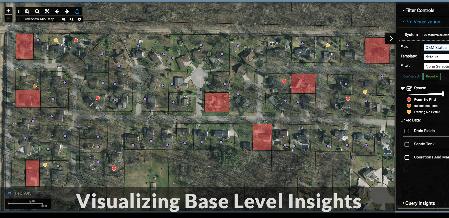
Base Level Insights
As of this post, we have mapped about 3200 systems in Bay County as part of the Kawkawlin River Watershed project. This represents about a quarter of systems we anticipate mapping for the project. Despite having many more systems to map, we are starting to understand more about the base level insights and benefits of developing a location-based inventory.
Here I refer to base level insights as those gained simply by mapping the inventory and working through each permit in the process. These are insights that do not require any higher end analysis tools in the software, but do provide immediate benefits.
We knew going in that we would better understand things like what parcels are not on sewer, but do not have a permit. As we map more systems, we are seeing additional areas where important information is missing for systems. These gaps in system information provide the opportunity to categorize systems in terms of what is known or unknown about them, which is another form of insights gained. For this project in particular, what information is present or missing is important as it identifies where site visits are required to fill in the information gaps, which ultimately lead to a better understanding of the characteristics of the inventory in the watershed.
I have categorized the information gaps below with a description. These represent the most common gaps we have experienced thus far, and when recorded as data, will provide base level insights about the inventory.
No Sewer - No Permit
These properties do not have public sewer and do not have an onsite wastewater permit on file. They represent systems with the least amount of information available and are the highest priority for site visits to fill the information gap.
Permit - No Final
These systems have been permitted, but there is not a final inspection attached to the permit. These can include new, replacement or system addition permits. While there is information about the system components on the permit, only site verification can determine if the system on the permit was actually installed. Further complicating matters, some of the permits have alternative plans for both tank capacity/number of tanks and disposal area types/size. The age of the system is also approximate and based on the permit issued date rather than the install date, if the system was actually installed in the first place.
Final - Missing Information
These systems have a final, but are missing information such as the tank size or disposal size. In these examples, we can use the tank and disposal size on the permit, but we have to flag the system to note that the recorded sizes are from the permit and not the final. What is actually installed can only be verified by a field visit and even then, it is often an approximation.
Replacement - Existing
These are systems where one component, such as the disposal area, has been replaced with a new permit and an existing component, such as the tank is used with the replacement component. The problem is that the replacement permit may not provide any information beyond ‘existing tank/field’ on the permit and the original permit for the existing component does not exist. So, the existing component size, type and age remains unknown.
Another common problem with replacement systems is that many replacement permits do not clearly state if the tank is crushed and filled or if the disposal area is abandoned or out of service. So, these components may still be present.
Incorrect Address/No Address
These are permits that are missing an address number and/or road name, or the address number and/or road name no longer exist in any records. We do our best to search property records to find a name match on a sales record, but often these permits can’t be mapped. So far, we have been unable to map approximately 7% of the permits we review. This does not necessarily mean that 7% of the inventory will be unmapped as many of these systems may have a replacement system or the structure the system served may no longer exist.
Fortunately, by mapping the systems, even with a point, we will always be able to update the address or property number in the future.
Base Level Insights
From a software, or GIS perspective, we tend to leap to the analysis and insights that we know the technology is capable of. These insights are the bells and whistles so to speak of embedded in FetchEH, and we will certainly implement these tools as the inventory grows. However, what we often overlook are the very fundamental insights and benefits gained simply by mapping a feature, in this instance onsite wastewater systems.
This is especially true in professions where location and data driven insights has not been widely used, such as the onsite industry. For example, Bay County has already experienced benefits simply by improving access to onsite information via an interactive map, where system information, PDFs, pictures and visualizations are readily available.
This is also true for the gaps in information noted in this post, which provide very real and tangible insights immediately. The idea of prioritizing inspections or site visits based on gaps in information is very useful for core onsite workflows and effective resource allocation. These are base level insights that are valuable to any community and build a better understanding of the inventory.
The key here is that the simple act of mapping the inventory uncovers many base level insights and benefits that help regulators – it helps them answer questions they were unable to answer before. We will get to the bells and whistle type insights in due time, but for now, the base level insights are a powerful reminder of the value of mapping these systems in the first place.