EH Bellman
Location, data and EH. A better way forward.
EH Bellman - March.20.2017
Converting Onsite Wastewater Permits and Site Plans
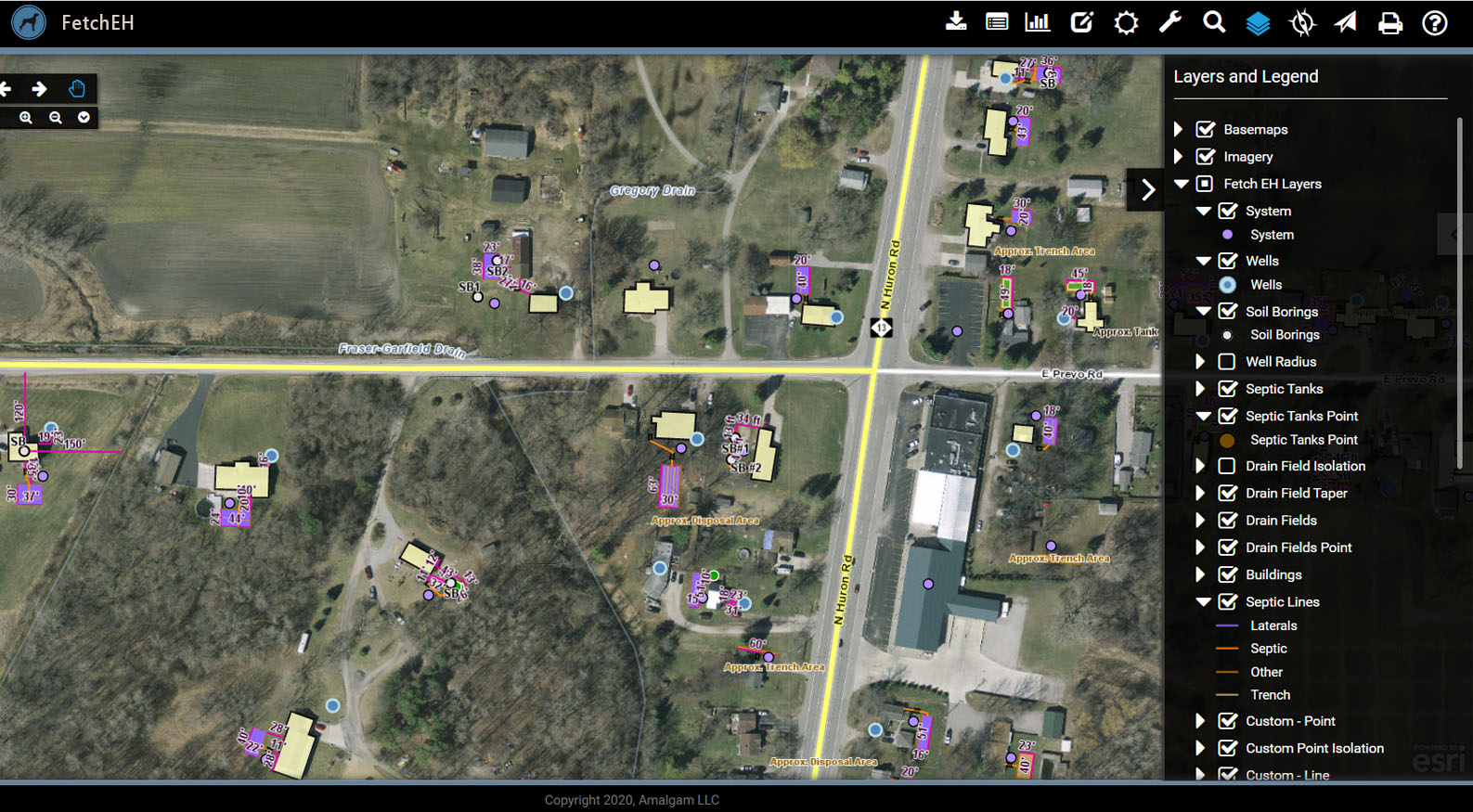
Amalgam and the Bay County Environmental Health Department are conducting a pilot to map existing onsite wastewater site plans and permits currently sitting in a filing cabinet. The objective of the pilot is to define a process and standards for effectively converting paper site plans into a digital format for use in the Environmental Health application. Mapping septic systems will improve access to septic system information to regulators, citizens and industry, and provide new opportunities to visualize information and ask questions about the data to better understand septic system characteristics across a community.
The site plans contain maps and permit information about onsite wastewater system features like the septic tank, drain field, soil borings, water well and more. Each site plan is being mapped, including adding information about wastewater features, using the Environmental Health application. The idea is to eventually map all site plan records in Bay County, including layers for septic tanks, drain fields, wells, soil borings, measurements, and control points, and capture any corresponding information such as tank size, drain field dimensions, number of laterals, permit number, installer, finalized date, soil profiles and more.
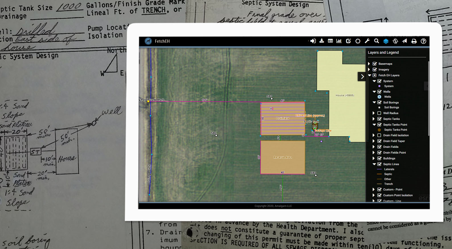
Mapping Onsite Wastewater Systems from Site Plans
Building a Management System
The wealth of information on the site plans and permits will be used to better understand private onsite wastewater systems in communities and provide new opportunities for data driven routines such as reporting, risk analysis and notifications. These data driven routines will be used to manage septic systems and move beyond simply permitting as a primary tool for regulators.
Once a septic system inventory is mapped, regulators can begin to ask questions about septic systems in the community, such as finding systems of a particular age or type, and then visualize the results on a map to better understand where these systems are located and understand their relationship to other features, such as adjacent septic systems, proximity to streams/lakes or poor soil conditions. These types of analysis options are only possible when septic systems have been mapped and can be used in combination with other map layers, such as parcels, soils, wetlands, elevation and lakes/streams, to identify vulnerable sites and ultimately implement programs that reduce the risk of failing systems and their impact to a community.
Improving Access
The benefits of mapping septic systems won't just benefit regulators. Improving access to septic system maps and data benefit home owners, home buyers and private wastewater professionals. For home owners understanding the location, age, history and potential system issues, such as poor soil conditions, can improve awareness of their systems characteristics and subsequent maintenance requirements. For home buyers, understanding these same system characteristics can help them make more informed decisions about a new home and potential costs related to the septic system. For industry professionals, septic system site plans and data can be used to locate septic tanks for pumping or inspections, while also providing the opportunity to contribute maintenance and inspection information back into the system.
Creating a Query for O&M Data
The pilot is expected to conclude in Q2 2017. To learn more about the pilot or the Environmental Health application get in touch.
More Posts