EH Bellman
Location, data and EH. A better way forward.
EH Bellman - October.30.2017
Digital Site Plans
Mapping septic system site plans in a digital format has many advantages over paper maps destined for the filing cabinet or even a PDF stored on a server. The benefits of digital site plans include improved accessibility by the public and internal staff, ability to represent the system accurately on a property, new workflow efficiencies through automation and improved data quality for understanding the health of septic system inventories.
These are all significant benefits that can lead to improving public health and water quality in our communities, especially when considering the use of septic system data to assess risk and gain new insights about systems in our communities. So, in this post we will discuss digital site plan benefits in more detail and see how they form the foundation of a modern management system.
Digital Format
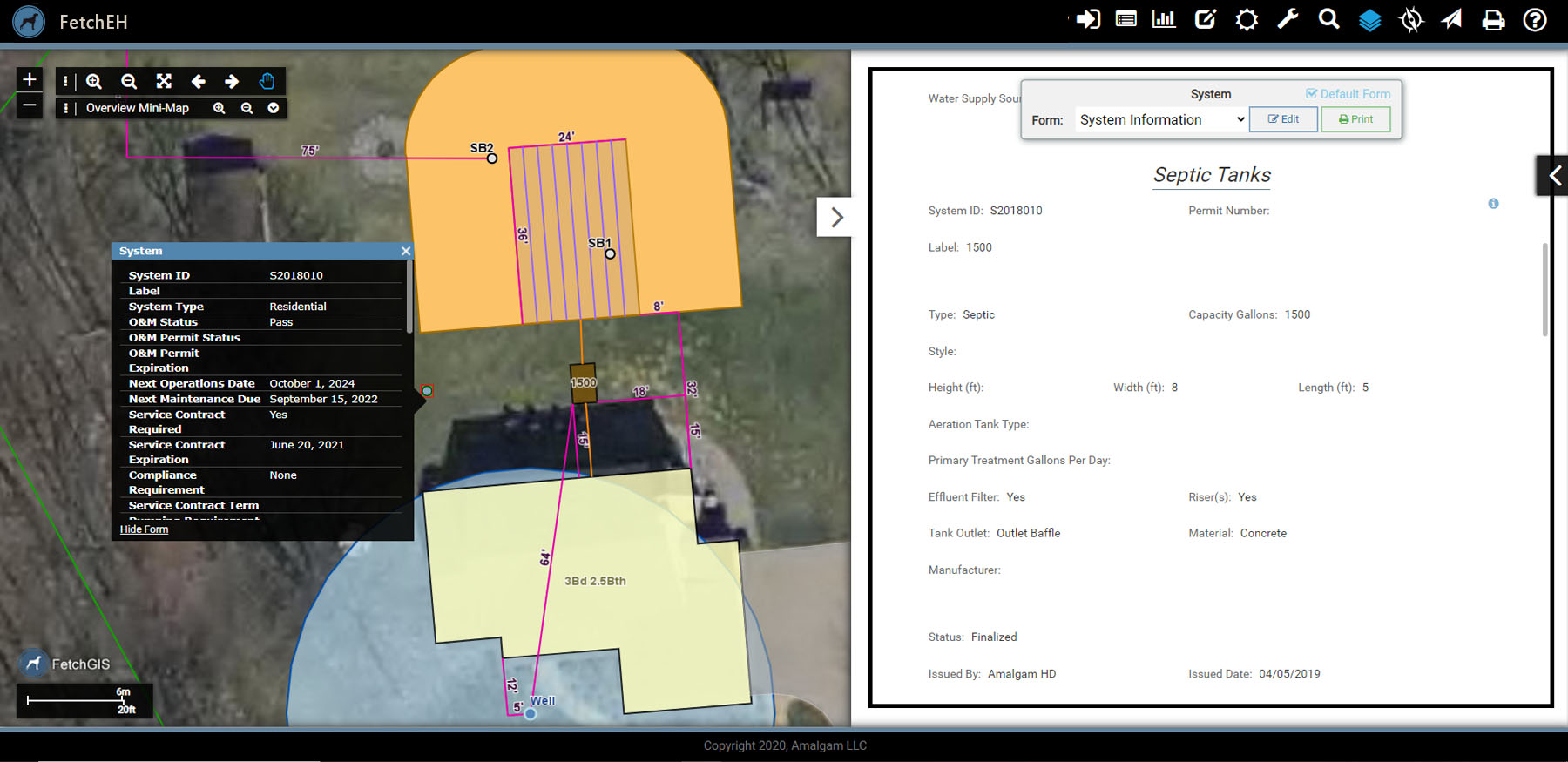
For starters we consider what 'digital' means as a PDF is technically a digital site plan too. In this case digital format means that the septic system site plan is intelligent and interactive. For example, information can be obtained about the location and layout of the septic system components using an interactive map, and information about each component can be accessed or viewed, such as the tank size, drain field size and type, install date, maintenance records and more. So digital in this sense means we can view multiple site plans on one map and use the information about each system to assess risk and gain new insights about systems across an entire community.
Improving Access to Onsite Wastewater System Information
Site plans managed in a digital format make it easier for the public, contractors, realtors and regulators to access septic system information, including visually understanding the system and its layout on a property, as well as discovering detailed information about each component and its maintenance history. Providing access to septic system information not only helps home owners become familiar with their system, it also reduces the number of requests to internal staff for these records. Digital site plans also establish a strong foundation of septic system data that can be used to assess risk and gain new insights about the health of the inventory.
To Scale
One of the common complaints we hear is that paper site plans, and even some digital sketches, are not to scale. This makes it harder to understand the relationships between system components on a site plan as distance and size are often distorted. Because digital site plans are developed using modern mapping tools, they are created to scale and are displayed on an interactive map that same way. This means that the relationship between mapped system components, such as the septic tank and drain field, are true without the distortion commonly found on paper site plans. For example, on a paper site plan the drain field may appear about the same size as the house, when in reality it is much smaller, or a 30’ measurement line on the site plan is drawn to be longer than a 40’ measurement line. Digital mapping preserves these spatial relationships so that they are to scale, they are accurate representations between septic system components as they exist onsite.
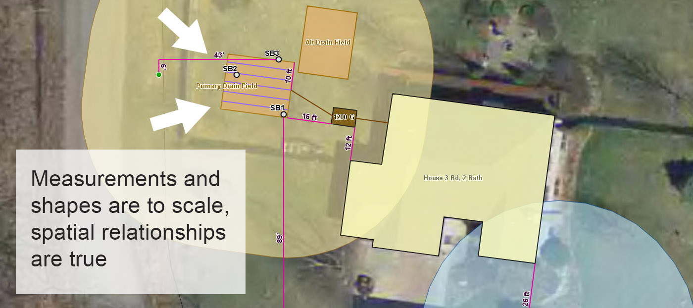
Site Plans Mapped To Scale
This is important because people consume information visually, so if it is not an accurate representation it is often difficult to understand. More importantly, the spatial relationships between system components can help regulators evaluate how systems interact with their surrounding environment, such as the distance to a neighbor’s well or septic system, offsets to the property line, proximity to wetlands and more.
True Location Represented
Another benefit of mapping site plans in a digital format is that the septic system is represented in its true location on a property – it is positionally accurate. That is, the septic tank, drain field and other components are displayed on the map where they actually are on the property. Accurate site plan maps make it easier for home owners, contractors and regulators to find septic system components more efficiently when onsite. For example, a homeowner can use measurement lines on the digital site plan to measure to a system component, such as the septic tank, while onsite, or enable GPS on their smartphone to literally walk to the system component on the map.
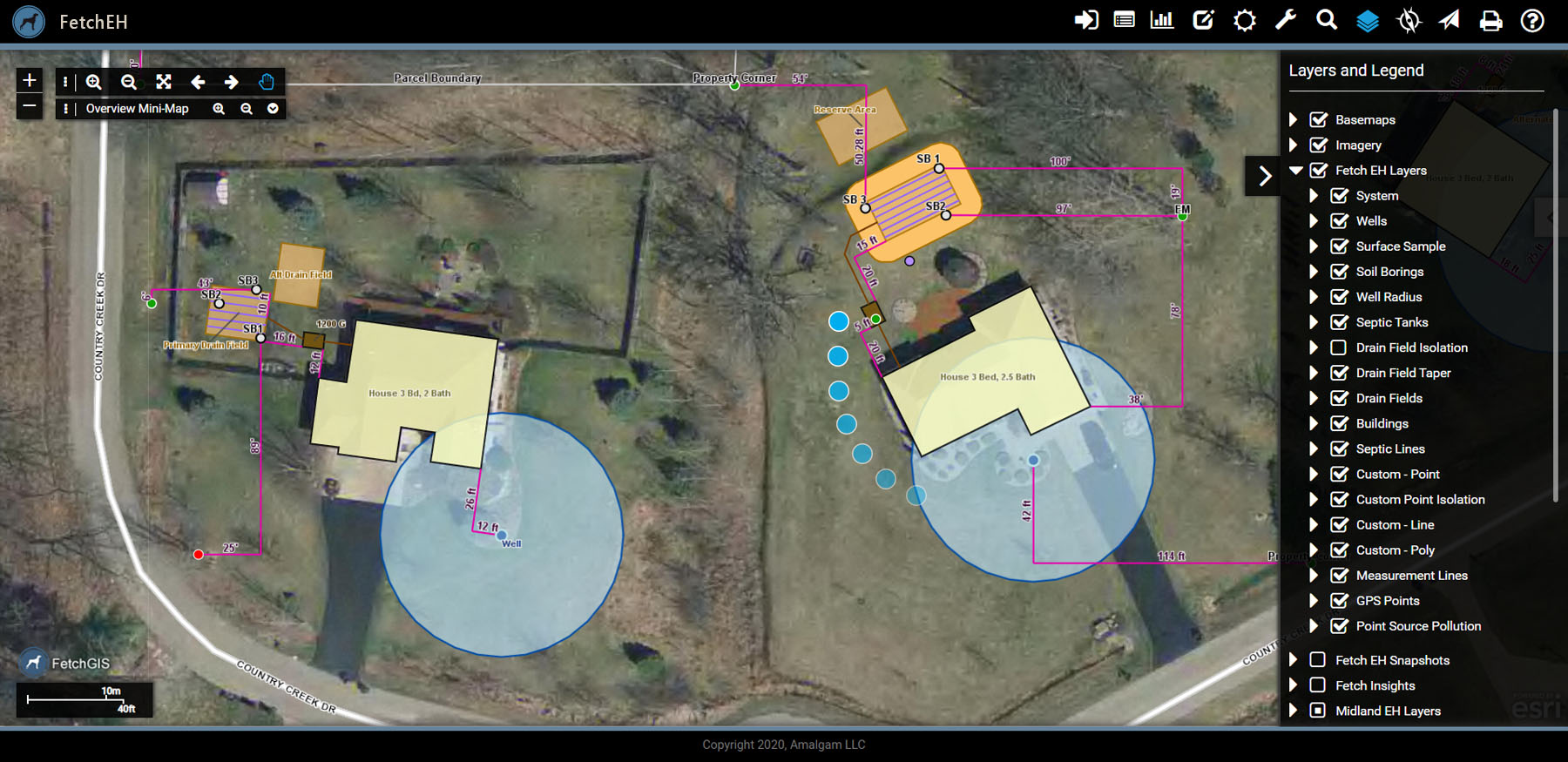
System Components Mapped In True Location
Mapping a septic system in its true location on the property also enables the use of location based variables and tools to assess risk. For example, the location of the septic system can be used to determine the density of systems, proximity to wells, streams or lakes, soil characteristics and more. Location based variables are also the way we consider the impact of failure when evaluating risk, rather than simply using system variables, such as age, tank size, drain field area, to assess risk. The combination of location based variables and system variables provide regulators a comprehensive assessment of risk, one that helps them prioritize where resources will be directed to have the greatest benefit to improving public health and the environment.
Digital site plans are the foundation to building good data, data that when used with modern mapping technology, helps regulators manage septic system inventories more effectively. The benefits of digital site plans make it easier for home owners, contractors and internal staff to access septic system information, introduce opportunities for automation and workflow efficiencies, and provide the location based information that helps regulators better understand and address risk.
More Posts